01 · UAV Survey
Drone survey & mapping
Land, topographic & Commune Land-Use Planning (CLUP) mapping; plantation assessment; RTK ground-control. SSCA-permitted operations under Decree No. 1644.
$500 – 2,000 / dayThe DCx AgriTech & GeoSpatial Intelligence Hub is a specialist technology and consulting venture led by DCx Co., Ltd, in strategic partnership with ADIC — designed to carry Cambodia from Agriculture 2.0 toward Agriculture 5.0–7.0. UAV mapping, GIS & remote sensing, AI analytics, climate-smart agriculture, carbon MRV and digital traceability — delivered as services, not as technology farmers have to buy.
AgriTech does not start from scratch. It is the geospatial-intelligence specialist within the DCx Co., Ltd portfolio — drawing on the data-science core, the AI/ML practice, the LABx STEAM programs and the consortium's project track record. The same brand, the same governance, the same standards — focused on agriculture.
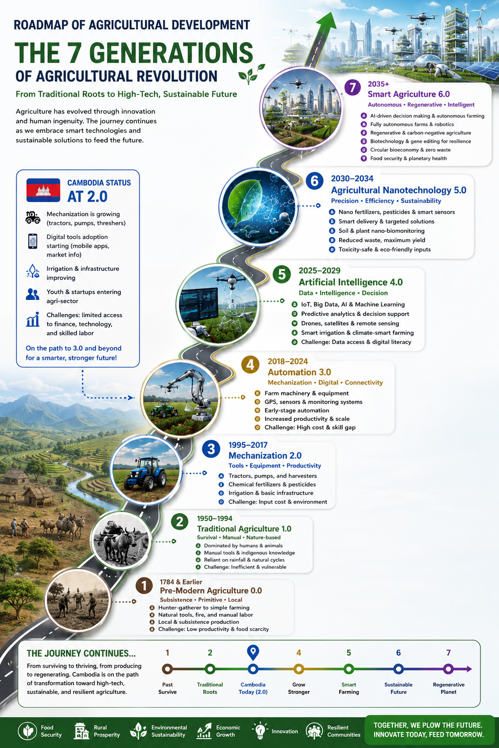
Cambodia doesn't have to climb every rung. Just as it leapfrogged fixed-line telephony straight to mobile, it can leapfrog directly into digital, data-driven agriculture. The enabling conditions are already in place — ~57% internet penetration, ~145% mobile penetration, a youthful population and 5G roll-out. The missing piece is an organisation that can deliver 4.0/5.0/7.0 capability as affordable services. That is AgriTech.
Global agriculture has moved through seven generations — from Traditional 1.0 (human and animal power) and Mechanization 2.0 (tractors and chemical inputs), through Automation 3.0 and Precision Farming 4.0, to AI & Big Data 5.0, Nano- & Biotech 6.0 and the emerging Future Agriculture 7.0 (autonomous farms, digital twins, blockchain traceability, carbon-smart regenerative agriculture).
Cambodian agriculture sits predominantly at Generation 2.0, with only pockets reaching 3.0 and 4.0. ~2.1 million smallholder households farm an average of 1.2 ha each. The 2024 diesel-price spike pushed some smallholders back toward draught animals; conservation agriculture covers ~0.12% of agricultural land. Precision tools exist only in donor pilots like CAPRED.
The productivity gap is not ambition — it is the missing data, intelligence and service layer between the farm and modern technology. AgriTech is deliberately built to be that layer.
Project-based services generate near-term cash and reference projects; the subscription platform builds recurring revenue; the academy develops talent — and feeds the team. The revenue mix shifts over the plan: UAV & GIS dominate early; carbon MRV and the intelligence platform become the principal growth engines by 2030.
Land, topographic & Commune Land-Use Planning (CLUP) mapping; plantation assessment; RTK ground-control. SSCA-permitted operations under Decree No. 1644.
$500 – 2,000 / dayLand-use, forest, fisheries and carbon mapping at landscape scale. Satellite imagery, classification, change detection, dashboards.
$5,000 – 50,000 / projectCrop-health dashboard, weather analytics, disease prediction. Subscription delivery to cooperatives, exporters and government — mobile-first.
$10 – 100 / farm / monthBaselines, MRV systems, satellite monitoring, verification support. Positioned as an independent MRV provider — fee-based, not exposed to credit prices.
$ per project · 5–6 figuresCashew, coffee, fisheries, organic rice. QR codes, batch IDs, EUDR-ready records — integrated with the FarmsNexus and CashEW ecosystems.
$10,000 – 100,000 / projectDrone pilot, GIS, AI for agriculture, KoboToolbox, carbon accounting. Builds a domestic talent pipeline and serves as a revenue line.
$100 – 1,000 / traineeA short flight from our team's own land in Cambodia. UAV Survey is the first service pillar — it isn't a brochure capability. It's the operation our team runs day-to-day, with the same equipment, same SSCA-permitted flight discipline and same delivery pipeline that goes into a client engagement.
What you're watching is the everyday output of the AgriTech UAV practice — a survey-grade drone mission over our own land. The same workflow scales to government CLUP mapping, plantation assessment for cashew or coffee, and forest / carbon baseline flights.
▶ Watch on YouTube ↗Two national geospatial portals DCx built and hosts for Cambodia's Community Fisheries (CFi) and Community Fish Refuges (CFR) — production apps on our own GeoServer stack, backed by PostGIS with React front-ends. Each card previews the live at-a-glance data; click to open the full interactive portal. This is what service pillar 02 (GIS & Mapping) looks like as a shipped product, available for your next commissioned engagement.

Community Fisheries (CFis) are Cambodia's locally-managed fishing grounds — communities co-manage inland lakes, floodplains and coastal mangroves for long-term food security. DCx built and hosts the national CFi portal that maps every registered CFi, its area, membership and governance — open data for planners, donors and the communities themselves.
First version developed by Open Development Cambodia (ODC) under FAO's CAPFISH Capture programme — Complementary Support to the Cambodia Programme for Sustainable and Inclusive Growth in the Fisheries Sector — with Dane So (DCx CEO) serving as FAO Technical Advisor for the Fisheries Information Management System (FIMS).

Community Fish Refuges (CFRs) are the sanctuaries that keep Cambodia's inland fisheries alive — dry-season shelters where broodstock survive to repopulate rice-fields and rivers in the wet season. DCx built and hosts the national CFR portal, mapping every refuge, its committee and its coverage in one open geospatial layer for MAFF, donors and communities.
First version developed by Open Development Cambodia (ODC) under FAO's CAPFISH Capture programme — Complementary Support to the Cambodia Programme for Sustainable and Inclusive Growth in the Fisheries Sector — with Dane So (DCx CEO) serving as FAO Technical Advisor for the Fisheries Information Management System (FIMS).
◆ Same reusable stack behind both portals: GeoServer for OGC-standard map services, PostGIS for the spatial database, and a React front-end for the interactive experience. Available for any commissioned Cambodia GIS engagement — fisheries, agriculture, land use, hydrology, protected areas.
AgriTech is built around demand that already exists across Cambodia — government, development partners, private sector and climate buyers. The DCx + ADIC network is already inside the procurement channels for each segment.
Agricultural statistics, crop monitoring, CLUP, fisheries-resource maps, protected-area & forest mapping, commune planning. Active programmes with ADB, GAFSP and CAPRED.
World Bank, ADB, IFAD, FAO, GIZ, JICA, UNDP, EU, USAID — survey, mapping, baseline, MRV and digital-agriculture consulting. Procurement channels DCx is already inside.
Cashew (~700K ha, USD 1.15B exports 2024), coffee, rubber, mango, agroforestry — plantation mapping, yield assessment, traceability. CashEW is the fintech bridge into the cashew chain.
Cambodia earned ~USD 11.6M from voluntary carbon credits (2016–2020) via Southern Cardamom and other REDD+ projects. AgriTech sells independent MRV, not credits.
Most survey firms offer drones and mapping but lack agricultural extension, community engagement and development-consulting depth. Software firms lack field delivery. AgriTech unites both — difficult to replicate and directly aligned with how government and donor procurement is scoped.
DCx leads the venture: software engineering, data systems, GIS & remote sensing, AI / analytics, digital-platform delivery. DCx owns the technology roadmap and holds the commercial and operational mandate — single accountable owner, clear governance.
ADIC contributes agricultural and rural-development field experience, community engagement, cooperative access, natural-resource governance and development-consulting credibility — capabilities essential to winning and delivering government and donor work.
Modular architecture, so each service line can be delivered independently or combined into integrated engagements. Every engagement follows the same workflow: scope & SSCA permitting → field capture → processing & analysis → QA → client delivery.
DJI Mavic 3 Enterprise RTK + multispectral platforms for high-resolution survey and crop health.
Emlid RS3 RTK survey equipment — centimetre-grade ground control for accurate ortho & CLUP outputs.
Open-source & commercial GIS stack, satellite imagery (Sentinel / Planet), change detection, dashboards.
Models for crop-health detection, disease prediction and yield estimation — DCx's AI / ML practice.
Mobile-first, offline-capable field surveys for ground-truthing & community-participatory data.
Cloud servers, dashboards, MRV documentation. Modular delivery — independent service lines or integrated.
A recent DCx data-science feasibility study delivered a parcel-level land-use inventory across ~10,000 ha of the Battambang / Chul Kiri irrigation district. The pipeline was assembled entirely from open-source geospatial tools — orchestrated through QGIS & Python, segmented with Meta's Segment Anything Model, and shipped as a print-ready cartographic PDF.
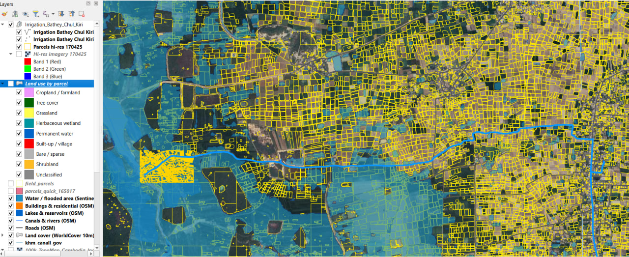
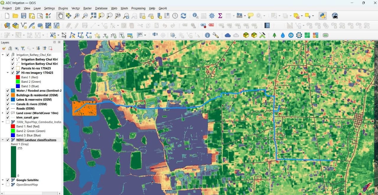
This land-use inventory was produced entirely with open-source geospatial tools orchestrated through
QGIS and Python (PyQGIS in a dedicated Conda
environment). Satellite imagery was sourced on demand — Sentinel-2 surface reflectance
via the Earth Search STAC API and sub-metre Esri World Imagery tiles —
and combined with the ESA WorldCover 10 m global land-cover product and
OpenStreetMap infrastructure data (Overpass API). Individual field/parcel
boundaries were delineated automatically using Meta's Segment Anything Model (SAM)
via the segment-geospatial (samgeo) library, running on
PyTorch with GPU (CUDA) acceleration to process the ~10,000 ha area as
110 one-square-kilometre tiles. Geometry handling, raster sampling, and the
per-parcel land-use tagging used GDAL, rasterio, and GeoPandas,
with Matplotlib for the summary chart, and the final cartographic layout (map, legend,
scale bar, north arrow, statistics) was assembled and exported to print-ready PDF with the
QGIS Print Layout engine.
Three sequenced phases — each one de-risked by the previous, each one expanding the service footprint. Reference projects compound into framework agreements; framework agreements compound into platform reach.
Stand up UAV survey, GIS services and the agriculture-intelligence platform. Secure SSCA permits. Win first government & donor reference projects with MAFF, FiA, MLMUPC, MoE and NCDDS.
Scale carbon monitoring, climate analytics & digital traceability. Expand into Laos and Vietnam through partnerships. Convert one-off projects into recurring platform subscriptions.
Regional AI-agriculture platform, digital-twin farms, carbon marketplace, full smart-agriculture ecosystem reaching across ASEAN producing economies.
Whether you're a ministry commissioning a survey, a donor scoping a programme, an exporter that needs provenance, or a partner exploring co-investment — there is a defined door for each conversation. DCx-led, ADIC-anchored, FarmsNexus-connected.
The leap from Agriculture 2.0 to 5.0–7.0 is technical, but the decisive ingredient is an organisation that can deliver the technology as a service. DCx leads it. ADIC anchors it. FarmsNexus channels it. CashEW finances it. Start a conversation about where you fit.
◆ Full business plan, financial model and partnership terms shared privately with qualified partners and investors on request.